
[ad_1]
(Edaily reporter Kim Hyung-hwan) Whether the rainy season, which is causing damage to the entire Korean Peninsula every day, will end remains unknown. This is because the uncertainty has further increased with the occurrence of Typhoon No. 3 “Ant” in the Philippine Sea.
|
“It is too early to predict the end of the rainy season now,” said Kim Young-jun, a forecast analyst at the Korea Meteorological Administration, in a routine briefing on the 21st, referring to the end of the rainy season. “It is difficult to make a judgment (due to high uncertainty) because of the influence of rain clouds caused by typhoons and the possibility of northerly air currents moving southward. “We can determine the exact date later by analyzing the data,” he explained.
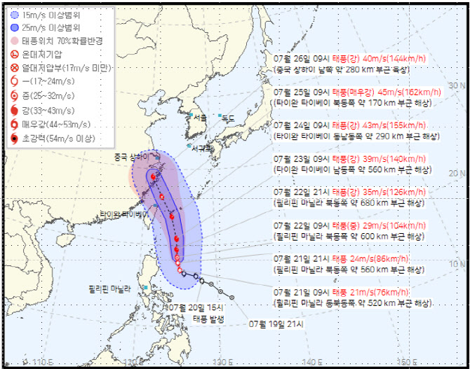
According to the Korea Meteorological Administration, Typhoon No. 3 “Ant” occurred in the waters northeast of Manila, Philippines. As of 9:00 that day, the central air pressure analysis was 994hPa (hPa). The typhoon is expected to move north or northwest, moving to northern Taiwan on the 24th and near Shanghai, China on the 26th. The Korea Meteorological Administration explained that although it is unlikely to directly affect the Korean Peninsula, it is too early to make a hasty decision due to the large volatility.
Due to the occurrence of the typhoon, the North Pacific high pressure is expected to move northward along the stagnant front located in the south. As a result, monsoon rains and hot weather are expected in the central region including the metropolitan area on Monday, the 22nd, and heat waves and showers are expected in the southern region. The western coast of Gyeonggi and the northern Gyeonggi region are expected to receive 80 mm of rainfall on the 22nd and 23rd respectively.
The Korea Meteorological Administration predicts that the North Pacific high pressure will expand and the stagnation front will rise toward North Korea on the 25th and 26th, presenting a calm state. The whole country is expected to experience hot and humid weather due to the high temperature and high humidity of the North Pacific high pressure.
The Korea Meteorological Administration explained that from the 27th, there will be great uncertainty and volatility depending on the intensity and path of the typhoon. The stagnation front that spreads monsoon rains is generated by the North Pacific High Pressure in the south and the dry areas in the north. This is because the position of the stagnation front changes with the rearrangement of the air pressure system, such as the North Pacific High Pressure. The place where Typhoon “Ant” disappeared is full of pressure. If the North Pacific High Pressure quickly returns to the position where Typhoon “Ant” disappeared, the stagnation front will continue to be on the North Korean side, but if it returns slowly, the stagnation front will move down to the south.
The Korea Meteorological Administration predicted through a medium-term forecast that from the 27th to the 31st, it will be cloudy with rain in Seoul, Incheon in Gyeonggi Province, and Yeongseo in Gangwon Province, and the rest of the country will be cloudy or rainy. Cloudy or overcast. Forecaster Kim explained, “After the 27th, the medium-term forecast fluctuates greatly due to uncertainty,” adding, “Please take a look at the medium-term forecast that will be announced later.”
|

[ad_2]
Source link

